Quick Assessment of Collapsed High-Rise Building Impacts During an Earthquake in Central Jakarta
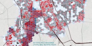
Introduction What would happen if a high-magnitude earthquake struck Jakarta—especially Central Jakarta, where numerous high-rise buildings dominate the skyline? Jakarta sits in a seismically active region and, despite not being …