Indonesia is a country prone to natural disasters due to its geographical location. The country’s situated at the intersection of several tectonic plates, and its terrain is characterized by mountain ranges, volcanoes, and a tropical climate with high rainfall. These factors contribute to Indonesia’s high disaster risk, including earthquakes, forest fires, floods, landslides, and volcanic eruptions.
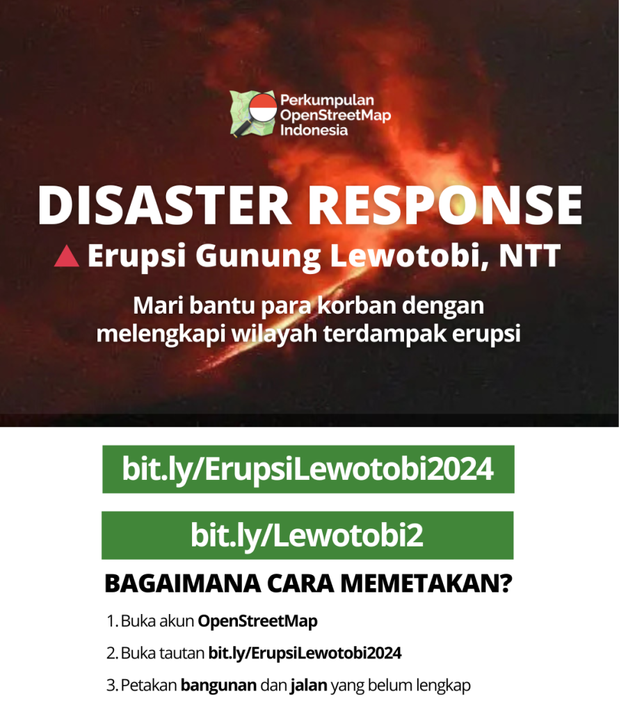
On November 3, 2024, an intense volcanic eruption occurred at Mount Lewotobi, located in East Nusa Tenggara, Indonesia. The eruption resulted in 10 fatalities, 63 injuries, and 12,200 displaced persons. The volcanic ash spread to several areas in East Nusa Tenggara, including Flores, Ende, and Labuan Bajo.
Mount Lewotobi’s activity was observed to increase from October 30 to November 5, 2024. On Sunday, November 3, 2024, at 23:50 WITA (UTC+8), a loud and powerful rumble was heard from the summit of Mount Lewotobi Laki-Laki. Before the major eruption on November 3-4, eight recorded explosions on October 30-31 produced ash clouds that reached approximately 1 km above the summit. On November 1, the PVMBG reported a significant increase in the number of deep volcanic earthquakes, and eight additional explosions produced ash clouds that reached approximately 2 km above the summit. Explosive activity continued to intensify, with Strombolian explosions at 02:50 and 04:20 producing eruption columns that reached 1.5-2 km above the summit; lightning was observed within the eruption column. No explosions were recorded on November 1 and November 3, although seismic activity remained high.
According to a report by the Center for Volcanology and Geological Hazard Mitigation (PVMBG), the height of the eruption column of Mount Lewotobi Laki-Laki was observed to reach 5,000 meters above the summit, or approximately 6,584 meters above sea level. The observed ash column was brown with a thick intensity towards the southwest, west, and northwest. In response to the disaster, the Indonesian government declared a state of emergency and built 442 temporary shelters for displaced persons. OpenStreetMap Indonesia (POI), as a disaster response-focused organization, conducted participatory mapping activities to complement the availability of spatial data in the affected areas. The OSM data around Mount Lewotobi proved useful for assessing building exposure, road access, alternative routes, shelter placement, aid distribution, and other critical information.
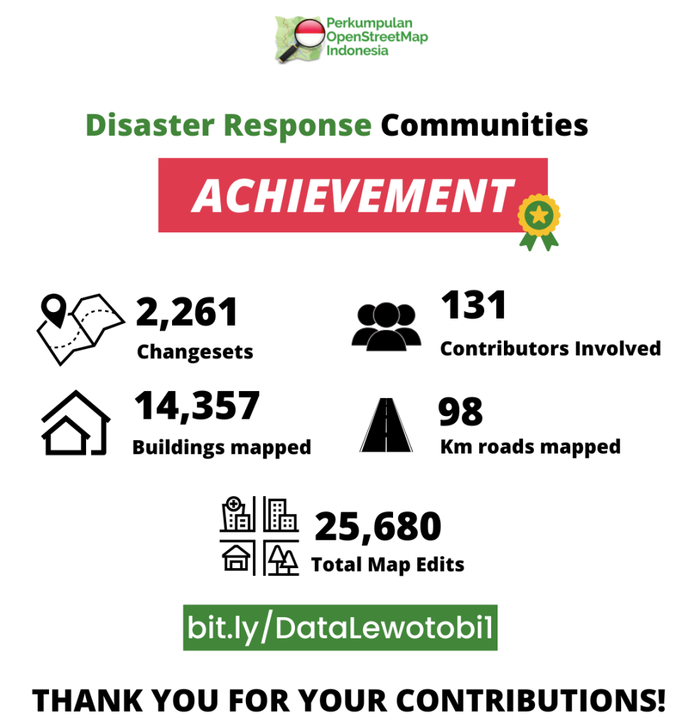
The participatory mapping activity was conducted in two phases, with 131 contributors participating in the disaster response effort. Using the HOT Task Manager tool, the affected areas were divided into grid-based work assignments to avoid overlapping work and ensure efficient data collection.
The participants showed enthusiasm, and the community’s mapping spirit was high. The results of the participatory mapping effort yielded 14,357 mapped buildings, 98 km of mapped roads, and 2,261 changesets, with a total of 25,680 edits. In the first phase itself, a total of 599 changesets were recorded from the contributions of 61 individuals, comprising 36 mappers and 14 validators. The first phase was completed with a total of 8,560 buildings mapped and 45 km of roads mapped. The contributors primarily focused on the key=value algorithm, utilizing building=yes for mapping buildings and highway=* for mapping roads. The highway algorithm itself was classified into several values, including:
- highway=trunk for National Roads
- highway=primary for Provincial Roads
- highway=secondary for Regency Roads
- highway=tertiary for Village Roads
- highway=residential for Local/Residential Roads
And other possible classifications for mapping purposes. Although other algorithms, such as river flow, land use, land cover, and even soil texture smoothness models, were also edited, assuming satellite imagery’s proficiency.
Following the participatory mapping activity, POI initiated the creation of a disaster risk map using the exposed OSM data collected during the mapping period. By overlaying secondary data from relevant agencies, such as the Indonesian National Disaster Management Agency (BNPB) and the Geospatial Information Agency (BIG), POI successfully analyzed the 2024 Mount Lewotobi Eruption Disaster Risk Map. The map revealed three disaster-prone areas, namely KRB 1, KRB 2, and KRB 3, categorized based on distance radii of 7 km, 5 km, and 2 km from the eruption center. Additionally, the map included a no-activity zone, located 9 km from the eruption center. Based on the OSM data, 5,937 buildings were affected, and the length of roads closed due to the eruption was estimated to be 123 km.

The participatory mapping effort conducted by POI in response to the Mount Lewotobi eruption demonstrated significant results, highlighting the importance of community-driven mapping initiatives in disaster response efforts. By leveraging OSM data, POI supported the government’s disaster response efforts, providing critical information for decision-making and ultimately contributing to the mitigation of the disaster’s impact.
The use of participatory mapping and OSM data in disaster response efforts has been recognized globally as an effective approach in enhancing disaster risk reduction and management (DRRM) efforts (UNISDR, 2015). The involvement of local communities in mapping activities enables the collection of accurate and up-to-date spatial data, which is crucial for informed decision-making in disaster response and recovery efforts.
Furthermore, the integration of OSM data with other data sources, such as satellite imagery and sensor data, can provide a more comprehensive understanding of the disaster situation (FEMA, 2020). This integrated approach can enable more effective resource allocation, damage assessment, and response planning.
In conclusion, the participatory mapping effort conducted by POI in response to the Mount Lewotobi eruption highlights the potential of community-driven mapping initiatives in supporting disaster response efforts. The use of OSM data and participatory mapping approaches can enhance DRRM efforts, provide critical information for decision-making, and ultimately contribute to the mitigation of disaster impacts.