In the bustling metropolis of Jakarta, the rapid expansion of highways and buildings is a testament to the city’s growth. Within six months, the highways expanded by an impressive 0.97%, while buildings increased by 0.02% in OpenStreetMap. A less well-known fact, though, is that an astounding 350,000 errors were made in buildings and 280,000 in highways due to this rapid development. This evolving face of Jakarta’s urban sprawl was not just a testament to progress; it also echoed the need for precision in the digital representation of our surroundings.

Illustration of Overlapping Buildings in OpenStreetMap
The consequences of mapping errors are significant and are frequently disregarded in the effort to expand data sets. This development of Jakarta’s infrastructure brought with it the possibility of problems with outdated mapping references, urban growth, and human error-related map mistakes. As OpenStreetMap’s growth data relies heavily on contributors – the presence of contributors with diverse geographic knowledge is adversely affecting the data quality. Moreover, the absence of standardization guidance for volunteers contributing to digital cartography in OpenStreetMap results in heterogeneous data and inaccuracies.
A primary cause of these errors was poor digitization caused by out-of-date reference mapping data. Many OpenStreetMap participants preferred to map remotely; some satellite photos were outdated. Moreover, the rapid urbanization of Jakarta has made matters worse by delaying updating satellite imagery that depicts the city’s expansion. In addition to needing to be updated, the disparities in the sources of the satellite data also affected the digitization’s misalignment and, worse, might cause overlap with other objects like roads or buildings.
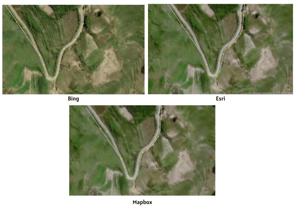
The Differences of Digitization in Different Satellite Imageries
These inaccuracies can result in various adverse effects, potentially leading to misunderstandings and flawed decision-making when relying on digital data to represent the city. Repercussions may include navigation difficulties, disruptions to daily business operations and logistics, and even a loss of public trust. To mitigate and prevent these negative impacts, Perkumpulan OpenStreetMap Indonesia (POI) and Kaart collaborated on the Mapping for Impact 2.0 event (previously with TomTom). Kaart, specializing in highway mapping for navigation, asserts that enhancing data quality necessitates the participation of local contributors due to the dynamic nature of OpenStreetMap data. This dynamic data has the potential to adversely affect navigation, leading to issues such as lost navigation or increased prices in online transportation due to error data.
Similar to the previous event, this event aims to enhance contributors’ awareness of data quality issues and diminish inaccuracies in OpenStreetMap. By engaging the local community, the event recognizes the crucial role of local contributors in OpenStreetMap’s growth data and the maintenance of data quality, given their local knowledge and deeper understanding of the actual conditions.
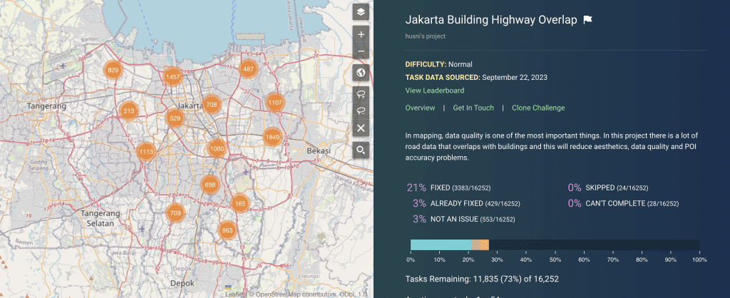
MapRoulette Challenge 41395 Jakarta Building Highway Overlap
The Mapping for Impact 2.0 event comprises a webinar and a competition series. The webinar, conducted virtually on Zoom on November 10, 2023, featured presentations on the consequences of inaccuracies in OpenStreetMap, specifically emphasizing highway cases—another presentation centered around the MapRoulette tutorial. The event’s competition aspect concentrated on fixing building and highway overlapping errors, which are identified as the most common issue in OpenStreetMap data in Jakarta. MapRoulette, a tool offering microtasks to OpenStreetMap contributors, was utilized to address errors categorized within a specific challenge.
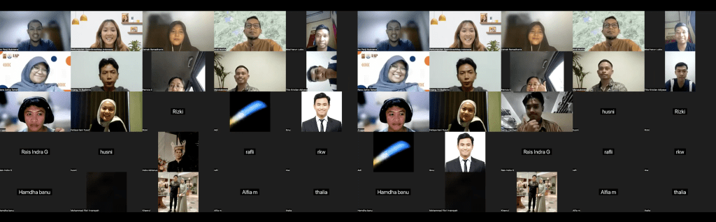
Group Photo of Mapping for Impact
Twelve contributors eagerly got involved in the event, lending their knowledge to improve digital mapping in Jakarta. Eight of the twelve participants are still active contributors, which indicates their experience and proficiency with OpenStreetMap mapping. With more than 4,000 issues resolved in just eight days, this had a significant impact. The 12 contributors mapped 1 km and made 6,835 modifications in total, including 498 new buildings. Besides a significant impact, the event served as an educational platform, offering participants valuable insights into data quality and expanding their understanding of the challenges in creating accurate and reliable maps. The top three contributors were selected after the event by POI and Kaart as the winners to receive an award for their hard work.
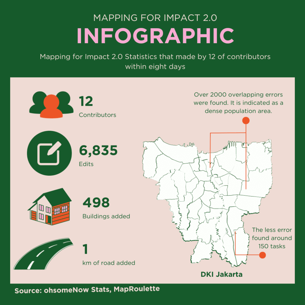
Infographic of Mapping for Impact 2.0
Mapping for Impact 2.0 was an innovative event beyond simple data visualization. In addition to the observable successes of improved data quality, the 12 committed participants created a lively sense of community. Motivated by precision and passion, the participants rose to the challenges enthusiastically and developed a more profound comprehension of precision’s critical role in geographic data.
This cooperative effort acts as a light as Jakarta’s digital ecosystem changes, reminding us of the critical role of accuracy in accurately navigating and depicting dynamic urban areas. Engaging local contributors is crucial to sustaining the accuracy and dependability of OpenStreetMap data, as demonstrated by the event’s success regarding the number of difficulties addressed and the sense of community formed.
As Jakarta continues to transform, Mapping for Impact 2.0 stands as a testament to the power of collective action, education, and the pursuit of precision in digital cartography. It supports the idea that with every precise map change, this event helps to improve data and produce a more understandable and informed urban scene. In the dynamic world of geospatial mapping, the event exemplifies the positive impact that a dedicated community can have on shaping the accuracy and reliability of digital representations for cities like Jakarta.